Get Involved
Become a Volunteer!
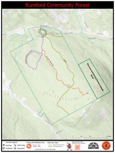
The project is the purchase and activation of approximately 446 acres of land on Isthmus Road in Rumford to create Rumford’s first Community Forest. The Rumford Community Forest will be open to the public for multiple recreational uses – hunting (with permission), fishing, snowmobiling, hiking, biking, snowshoeing and skiing. It will be managed for forestry using exemplary forestry standards, and for wildlife habitat and ecological conservation. Inland Woods + Trails owns the land and manages it as a community forest. The Trust for Public Land facilitated the acquisition of the property and public fundraising, and the Northern Forest Center assisted with the community planning process. Funds to purchase the land have been secured and IWT closed on the property in February 2024. Additional fundraising efforts continue to cover trail-creation related expenses. In March 2026, IWT acquired through a generous donation an additional 52 acres known as the Lucy and Christy Pachios Woods of the Rumford Community Forest.
The public had the opportunity from May 2023 through June 2024 to provide input into, and help inform decisions on the future management and uses of the Community Forest through a public planning process, hosted by the Rumford Planning Board, that was open to all. New trail build preparation and design began in the Spring of 2025 with the completion of an All Persons Trail in August and the Porcupine Ridge Hiking Trail and the Rumford Adventure Trail completed in September. The trails and forest can be accessed at 161 Isthmus Road.
Visit our Resources page to see the forest management plan.
July 2024: NOTE: Lichen Ledge hiking trail is currently closed.
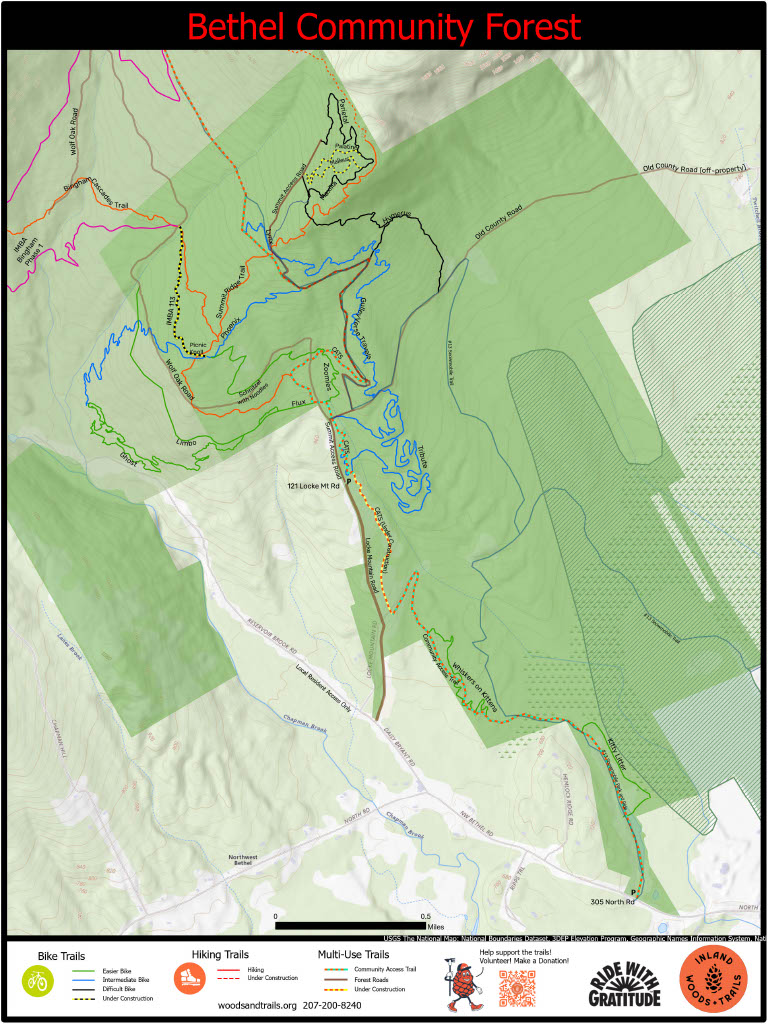
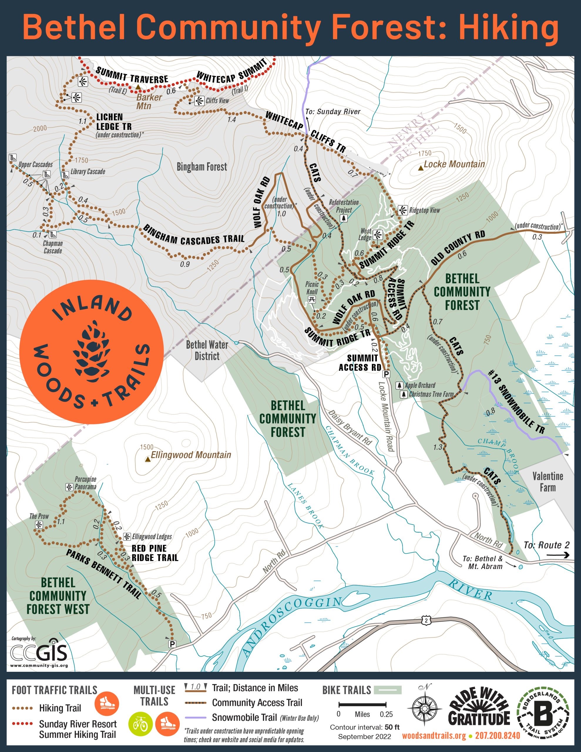
In 2019, Inland Woods + Trails, purchased the Bethel Community Forest. This 978-acre forest was acquired in collaboration with the Trust for Public Land and the Northern Forest Center. Since 2019 a variety of hiking and mountain biking trails have been built. In November 2022, Inland Woods + Trails and The Conservation Fund partnered to expand community recreation and prevent fragmentation of historic working forest by adding an additional 532 to the forest. The two organizations partnered again in 2023 to add an additional 28 acres to the forest with Inland Woods + Trails’ intent of using this newly acquired land to build a much needed trail center and limited primitive campsites.
Inland Woods + Trails has hosted the “Plant it Forward” event series. So far over 17,000 trees have been planted in the Community Forest as part of efforts to restore the landscape to a more balanced ecosystem. The goal is for an exemplary forest that supports biodiversity, reduces erosion, enriches soil, and hosts healthy wildlife habitat.
The Bethel Community Forest is also managed to protect the feeder streams to Chapman Brook and the Androscoggin River and to protect one of the most productive deer wintering areas in the state.
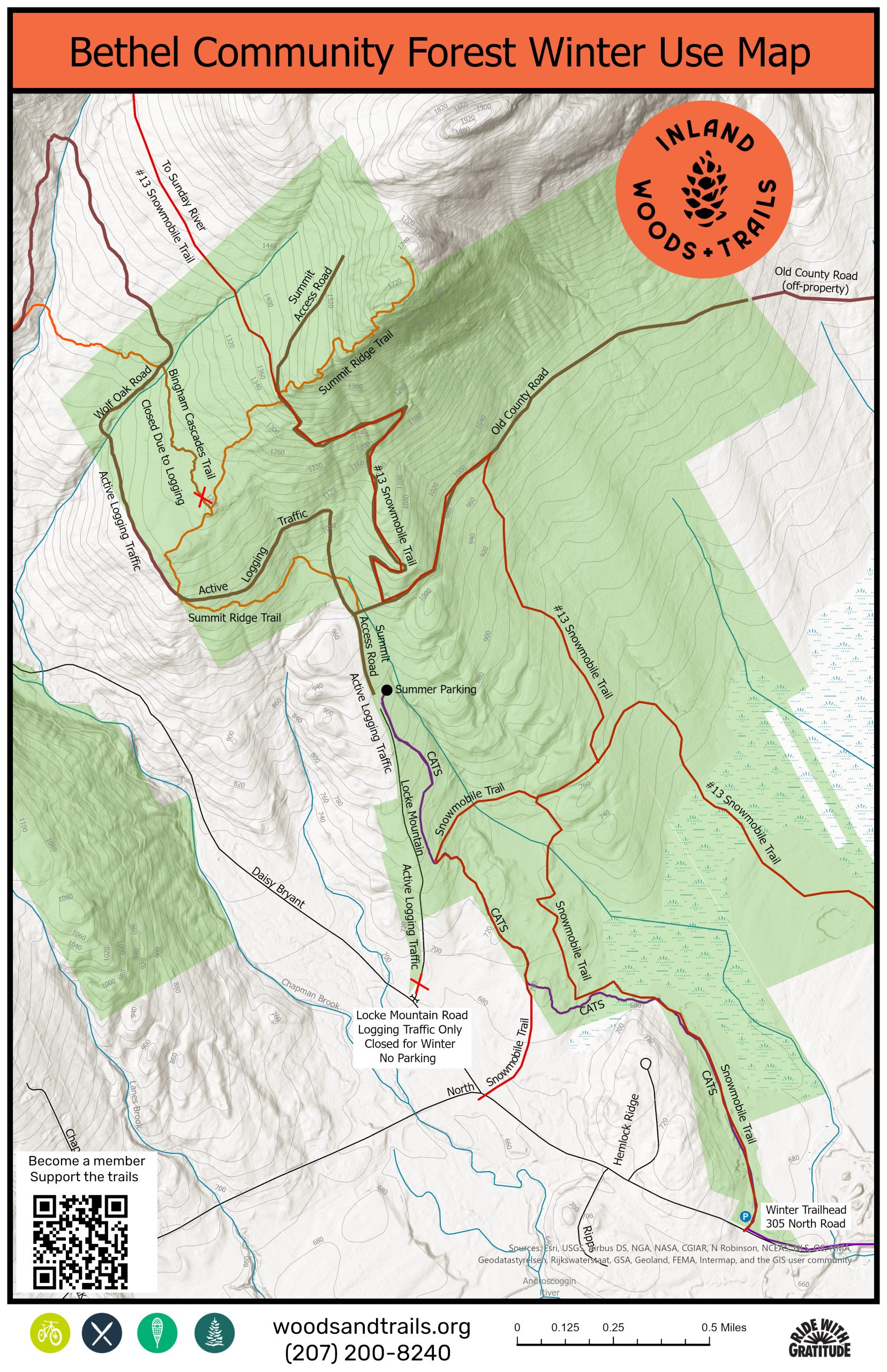
In the fall and winter the forest is open to traditional recreation uses such as hunting (with permission) and snowmobiling.
Visit our Resources page to see the forest management plan.
Bethel Community Forest West (BCF West): BCF West is a 532 acre forest originally part of the Chadbourne Tree Farm forest network. In 2020, the property was sold, along with nearly 15,000 acres of Chadbourne Tree Farm land to The Conservation Fund (TCF). In 2022, it was purchased by IWT and converted to the Bethel Community Forest as part of the Chadbourne Conservation Partnership plan.
Currently there are 3 miles of hiking trails and the trailhead can be found at 753 North Road, Bethel ME.
The connection: When Inland Woods + Trails was founded, a foundational goal was to connect Sunday River to the Bethel village through a system of trails. The Bethel Community Forest and Bingham Forest are enormous puzzle pieces in IWT’s mission to create a 3,600-acre tapestry of conserved land to connect communities of Bethel and beyond with the peaks of Sunday River. These forests host trail corridors that will allow travel from Bethel to Sunday River via a traditional hiking trail, a single-track bike trail, a multiple use double track trail, or a snowmobile trail.
Bingham Forest: The 2,358-acre Bingham Forest was conveyed to the Bethel Water Company in 1925. In 2007, a torrential rainstorm severely damaged a brook in the forest which was a key part of the infrastructure for the drinking water supply for Bethel. The town then shifted to sourcing water from subsurface wells, and in 2010 the trusteeship of the forest was conveyed to the Town of Bethel. The Bingham Forest is managed for watershed protection, wildlife habitat protection, public recreation, and sustainable timber management. Inland Woods + Trails serves as the recreation managers for the forest.
In 2019, a clear route of access was available to the Bingham Forest when IWT purchased the Bethel Community Forest. In 2020, the Bingham Cascades Trail was built off the Summit Ridge Trail. It travels through the Bingham Forest and visits a series of waterfalls and cascades. In 2021, a single-track mountain bike trail “Flux” was built as a connector from the BCF to a bike trail located on Bethel Water District land called “Ghost”. Additional single track has been built since then, and various double track woods roads have been rehabilitated for recreation use.
During at least the next two winters the Town of Bethel will be conducting a timber harvest in the Bingham Forest.
What does that mean for Bethel Community Forest visitors in the winter?
Become a Volunteer!
Support Them by Making a Donation!